Welcome

Center for Information Technologies - CIT
Center for Information Technologies
HYDROINFORMATION TECHNOLOGIES
CIT is recognized as a regional leader for software development in hydroinformatics and it became principal partner to National institute for water resources management.
Equipped with PLC microcontrollers and hydrology measuring devices, add-on modules are used with SCADA software for automated measurement and control. Several sensors are developed at Centre (e.g. ultrasound sensor for water lever measurement), and many commercial devices (Geokon, ELE, etc.) are applied in hydro-meteorological and hydro-geological measurement systems designed at CIT.
CIT is equipped with mobile hydro-meteorological station and water quality measurement system, with telecommunication unit, which can be applied on various sites in the region.
What is hydroinformatics?
Hydroinformatics is a basic discipline of hydroengineering. It provides sustainable growth of water environments by using computers and networks. Hydroinformatics deals especially with modeling the information related to hydroengineering, as well as distributed platforms based on information and communication technologies, in order to improve design, performance, management and administration.
Hydroinformation technologies
Software solutions:
Hardware solutions:
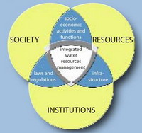
Integrated water resource management.
Versatile usage of water resources makes a foundation of entire region’s development. The research and advance in water resources usage is conducted by multIdisciplinary teams, because it is necessary to apply sophisticated expert knowledge in multItude of areas in order to achieve certain results. One comm on thing to all these areas is the need for data acquisition, systematization, and processing at large scales, as well as a possibility to simulate real and hypothetical systems.
Institute for the development of water resources "JAROSLAV ČERNI"
is a central non-government institution for research, development, design and consultancy in the fields of hydraulic engineering and water management. Established in 1947, the Institute was named in the honor of its first director, distinguished hydraulic engineer. During more than 50 years of its activity, the Institute has grown into the largest and leading organization in water domain in Yugoslavia.
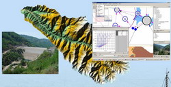
Hydroinformatic systems
The goal of design and implementation of distributed hydroinformatic systems is to create conditions for optimal water resource management and solving current and potential conflicts in region in relation to opposing interests and development projects. That way, the transparent and independent help for watershed management is provided, the demands for electricity production are synchronized, and the risk of flooding reduced with water quality improved.
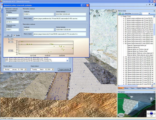
Database
In order for simulation model to function properly it is necessary to provide well formed and organized database that should consist of: hydrometeorological data, users data, system configuration, hydrographic network, channels characteristics, etc. Large amount of heterogeneous data and the need for interoperability together determine intense use of common GIS standards.
Mathematical simulation
Mathematical simulation of system and related processes is required to give user information needed to make expert decisions for further development and current water resource management. The simulation model is a base to complex software solution for integrated watershed management support and represents mathematical model of water flow from the moment of rainoff creation to the moment the water leaves the drainage area.
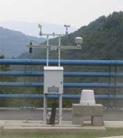
Data measurement, acquisition and transfer
The proper functioning of hydroinformatic system requires precise data on measured values that act as model inputs. In order to achieve that, it is essential to design modern systems for acquisition, archiving, and distribution of relevant meteorological, hydrological measurements as well as water usage data. The system consists of: measurement stations network, data transfer system, data processing and prognostics software and database.
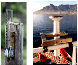
Custom sensors development
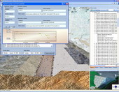
Regarding to users needs new types of intelligent sensors and specific data transfer and archiving systems are developed. These systems are designed to measure hydrometeorological data in specific conditions, as well as many geodesic and geological values related to stability of dams, tunnels, excavations, etc.
Hydroinformation system for hydropower plant Trebisnijca

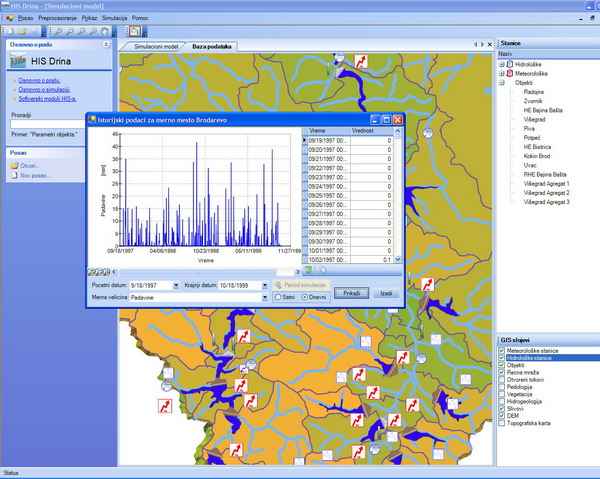
Hydroinformation system for Drina river basin

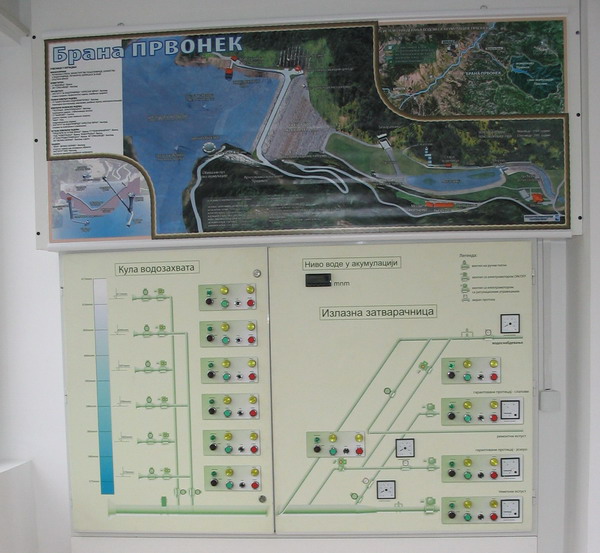
Hydroinformation system for Prvonek dam
 Cooperation
Institute JAROSLAV CERNI A.D is independent institute for research, development, design and consulting services in the fields of hydraulic engineering and integral water resources management, including vast range of services ranging from basic and applied studies and investigations, through water master planning, feasibility studies and designs, to complex multidisciplinary projects.
 Data measurement, acquisition and transfer
Hydroinformatics is concerned with the application of information and communication technologies for the
planning, management, and conservation of the aquatic environment.
 Activities of the Center
Research and development in the area of information technologies, engineering software and designing
and implementation of computer operated systems, especially in area of information systems building
and hydroinformatics.
 Educational activities
Organizing of educational activities in the spheres of information technologies, engineering software and
designing and implementation of computer operated systems. Publication activities (printed materials,
electronic multimedia releases - CD, DVD, internet and eLearning contents).
 Cooperation
Research conducted at the
University of Kragujevac in collaboration with world renowned institutions such as: M.I.T., the Technical
University of Athens, the Imperial College, Harvard University, the Hong Kong Polytechnic University,
Nanyang Technological University Singapore, and in conjunction with domestic and foreign industry.
Address: S.Janjic 6,
34000 Kragujevac, Serbia
Tel/Fax: +381 34 304710
E-mail: gruja@kg.ac.rs